Tuesday, March 19, 2013

Mojave National Preserve to Yucca Valley

We ended up spending two nights at the foot of the Kelso Dunes. My friends from Los Angeles left late morning heading for Utah and we had the place pretty much to ourselves. I felt crummy from the head cold I’d come down with so took it easy staying in the shade and reading. Another cool night with a stunning display of stars.

P1240252The next morning we headed out towards Yucca Valley and Joshua Tree National Park. Along the way we managed to drive a bit on old Route 66. Near Amboy, CA the map showed a little town called Bagdad. I wondered if it might be home of the Bagdad Café made famous by the German movie from 1987. I went in search of Bagdad and its café but the town no longer exists. It gradually disappeared after the Interstate Highway by-passed this section of Route 66. The movie was filmed up the road in Newberry Springs, CA (about 50 miles west of the original).

This is the café and gas station in Amboy, CA today. The old Route 66 surely never saw gas prices this high ($4.99/gallon).

P1240253

Not far from Amboy is the Amboy Crater. Ten thousand years ago a volcanic eruption created this crater and left a lot of lava lying around.

P1240254

Another hour or so of driving got us to the town of 29 Palms which is one of several places where you can head into Joshua Tree National Park. We ended up spending the next two nights at a campground above the town of Yucca Valley. The campground was at 4,000 so the night’s were cool and comfortable.

P1240257

There are Joshua Trees everywhere and these were the ones assigned to our campsite.

Sunday, March 17, 2013

Death Valley N.P. to Mojave National Preserve


P1240226
I couldn’t imagine spending another day in the heat of Death Valley although it was supposed to moderate somewhat. Although the vastness is impressive, there really are no activities that I could imagine undertaking in such temperatures although I did see people on bicycles and people were out hiking. In any event, I was leaving Death Valley by the southern route which meant passing some of the major sights along the way.
One of those sites is Bad Water ... the lowest point in the U.S. at –282 feet below sea level. On the wall behind the parking lot, there’s a sign on the cliff indicating sea level. A very odd sensation to realize that sea level is to high above.

P1240219
Of course a lot of Death Valley is below sea level. I just never realized how much. You can drive for miles and the GPS keeps telling you that you are 100 to 200 feet below sea level. It’s not just one spot but a large part of the whole valley.


P1240222
The Salt Flats at Bad Water

The road south winds along the eastern side of Death Valley actually allowing you to drive in the shade most of the way at this time of day. There are a couple of small passes to get up and over but nothing like the torture of entering the park from the west on Hwy 190.

P1240228
As soon as we began rolling down from Salsbury Pass, it seemed that the air was cooler. Then again, perhaps it was just my relief at leaving Death Valley after such a short visit. This northern gringo had had enough. Connecting with Hwy 127, we headed south through desert that was not quite so stark as D.V.N.P. There’s a huge area of sand dunes that were very impressive but it wasn’t easy to get a good photograph. They appear to mostly be used by people with OHVs (Off Highway Vehicles).

There was still lots of nothing to drive through. I wasn’t sure where we would spend the night. I thought we might make it as far as Joshua Tree National Park. But we got slowed down by the Mojave National Preserve.

P1240232Death Valley is stark. There’s very little vegetation just rock and sand. But Mojave National Reserve which lies just south of Death Valley is a whole other landscape. It’s a huge, unsettled area that runs between two interstate highways. In the middle of the park at Kelso there is a visitor center.
Back in the early days of the Southern Pacific Railway Kelso was an important center where engines were added to help pull trains up and over an especially steep grade. With the coming of more powerful diesel engines, the center was no longer needed and the town that the railway had created died away. The trains still go through Kelso and the lovely old railway station is now a visitor center with a lovely retro café and ice cream parlour. (I don’t actually think it retro ... I think it’s the real thing.)

P1240234
P1240235
A little south of Kelso there’s a very washboardy road that goes off to the Kelso Dunes which rise about 800 feet above the desert floor which is already at 2,500 feet.
It’s a slow three mile drive to the dunes trailhead (depending on your vehicle’s suspension). And a little past the trailhead, there are a couple of places where people have traditionally camped free. I still hadn’t decided where to stop so thought I’d check them out. The second spot, about a mile from the dunes trailhead, was under some shade giving trees. There was already a van and a truck parked there but there was lots of room so we stopped and popped the top of the van.
P1240242
(Can you spot Eliot?)

My neighbours were very friendly. They work in the television and film industry in Los Angeles and were going to their home in Utah. The husband does set construction for a TV series called “Go On” which I assume has been renewed as they talked about work beginning again in July. The wife works as her husband’s secretary. She adored Eliot.
And so we camped in one of the nicest and quietest spots yet. And you sure couldn’t beat the scenery.
P1240243

Saturday, March 16, 2013

Panamint Springs, CA to Death Valley N.P.

Tried to get a jump on the heat this morning and got on the road before 9 a.m. (It was the best we could do.) The road up to Towne Pass is long with very few crazy switchbacks or hair raising turns. But it is a very long climb. Mile after mile in third gear; sometimes in second. One problem with crawling along at low speed is that there is less air flowing through the radiator. The temperature gauge was leaning scarily to the right so we stopped before the summit to let the old VW’s engine cool down.

P1240200

Towne Pass is just under 5,000 feet. The downhill into Death Valley proper was a fun coast with no more fear of engine overheating. Coming down from the pass, my first impression was of how vast the valley is.

We rolled into Stovepipe Wells where there is a campground near the road which has not a lick of shade. Mostly RVs but nowhere to plug in to run the air conditioning. Fortunately there was a shaded area beside where we parked. It was 10:30 a.m. and this is what the thermometer read.

P1240203

Sure it may be a dry (very dry) heat but it was very hot. Around this time I noticed that my nose was running and I kept sneezing. I’ve never been one for allergies but I thought: “There must be something in Death Valley that I’m allergic to.” Turns out I was just starting to come down with a head cold. Just the things to have in 37-38C heat.


By the time we stopped at the Furnace Creek Info Center, the temperature had continued to rise.

P1240217

Before the temperature could rise even further, I headed off to the nearby campground to select a site. There was lot of choice so I set up camp and the tarp for some shade. Really, in that sort of heat, sitting quietly in the shade drinking lots of water seemed the wisest move.

A little later in the afternoon when the sun had gotten a little lower in the sky, we made a trip  a little bit south and did the Artist’s Drive. It’s a narrow, one-way road that winds up into some picturesque hills.

P1240213

Then back to the Furnace Creek Visitor Center to see if their wi-fi was working (it wasn’t). So nothing else to do but go a short way up the road to the Furnace Creek Ranch for Diet-Coke and an ice cream sandwich. Then back to the campground where, about three campsites from me, two gay guys were attempting to assemble a new tent. It had to be new as they were having little success determining which poles went where. After about ten minutes I could stand it no longer and walked over to if I could help out. A few pointers and the tent was finally up. During my days at MEC, I always advised people buying a new tent to take it home and set it up in the backyard so they would know how to do it in case their first time in the bush it was raining or dark.

In the desert, you can usually count on things cooling off a bit once the sun sets. But Death Valley is surrounded by mountains so it seem that the heat sort of just recirculates on itself. So there was relief in that there was no longer the hot sun beating down, but it was still fairly warm ... I’m guessing 30C or so.

Now this brings me to something I’ve yet to understand. Campfires. I can understand the attraction of the campfire when camping – especially if it’s cold and damp. The primal attraction of heat and light. But I was fascinated that in the heat of Death Valley, as soon as it got dark (and even before), people still had to have their campfires. I was still sweating in a t-shirt and shorts. What was this about?  I will never understand it. It’s almost like some sort of mania that takes over and can’t be resisted. Of course, I ended up downwind of some of this wood burning which didn’t go well with my wish for unpolluted air nor my head cold that was settling in nicely at this point.

But I got my revenge because in the middle of the night a huge wind came up. All around me I could hear shrieks and car doors slamming as tents got tossed around in the wind. Even if campers had had the forethought to stake their tents, the ground did not easily accept a tent peg so I was witness to some minor destruction in the morning as it was clear some campers had moved to their cars during the night.

Friday, March 15, 2013

Lone Pine, CA to Panamint Springs, CA

A lovely quiet night at the Tuttle Creek Campground until the ‘host’ or someone who was staying with them started up their damn diesel engine truck at 6 a.m. and left it running for ten minutes. Really what is in (or not in) people’s heads.
P1240184During the night I had thought I heard running water. In the morning I could still hear it and thought maybe it was someone with a huge RV running a generator. On investigation I found a lovely mountain stream running between two parts of the campground. I suppose the line of trees growing along the stream's route should have been a tip off for me.
This area is called the Alabama Hills and behind the hills sits Mount McKinley the tallest peak in the lower 48 states. A fellow from Oregon that I was talking to said he’d seen people preparing for a summit attempt and had seen their lights high up on the mountainside the night before. P1240183
This fellow was also travelling with companions – his wife and two whippets. He said that they were taking the whippets for rattlesnake aversion training on Saturday somewhere south of Lone Pine. As he described the process, the dogs are exposed to rattlesnake(s) that have had just had their venom milked and then been muzzled! This was combined with shock collar training which he said they’d had had good success with with the whippets. Later on I was thinking about this story. I am pretty gullible and pretty much believe what people tell me. I wondered if the guy was having me on. In any event, I would have gone along just to have seen how one muzzles a rattlesnake!
P1240193
We finally got underway and I stopped in town to use the wi-fi at McDonald’s. The place was packed as it was noon and there is a high school across the street. After getting caught up internet-wise, I was able to park in the shade and pick up some groceries. The guy in front of me when I was checking out was this lively old geezer. I was only half listening to his conversation with the woman who was on check-out. But then I realized that he was clearly flirting with her. They bantered back and forth. Actually he bantered; she just mostly looked stoic and slightly embarrassed. When it appeared he’d left, I advised her to ask to see his bank balance before making any decisions. (You never know he might have found lots of gold in them thar hills.) In any event, in the middle of my checking out he returned and passed her his phone number which he’d written on the back of his receipt. I did note that she didn’t throw it away.
Then it was off down Hwy136 to connect with Hwy 190 and head for Death Valley. Despite the scorching temperatures forecast I thought it best not to miss the chance to see this place I might not have the opportunity to return. There are two mountain passes that you have to get up and over before you’re in Death Valley proper. The first isn’t terribly high and the VW pulled us up and over without problems. We rolled down the other side into Panamint Springs. There’s a commercial operation there that was grandfathered in when the park was expanded. There are cottages, a restaurant with a nice veranda and a campground for tents and other campers. There is almost no shade and as we had descended from the pass the heat really came on. Blistering heat especially in the sun. So I found and paid for a campsite and then put up my tarp to wait out the heat. From the campground the road leading up to the next pass was in clear view.
P1240197

Thursday, March 14, 2013

Lake Isabella, CA to Lone Pine, CA


With the forecasts for really hot weather in Death Valley I had almost decided to give it a miss. Who knows if I would ever get back but I didn’t want to risk endangering Eliot or Helmut (the VW van). But as the forecast was for lower temperatures by the weekend, I thought we would slowly make our way over the mountains and miss the worst of the heat.

First thing on this morning’s agenda was to purchase some new mantles for my Coleman lantern. The evening’s are so pleasant after the heat of the day that it’s nice to sit outside and read for a bit in the evening. So before leaving town I visited an Army/Navy surplus store in Lake Isabella. I tied Eliot just outside the door but when I went inside the two woman looking after the place asked if that was my dog and insisted that I bring him inside. Eliot and I did a little tour around the place and I found this lovely chapeau which has a detachable piece which covers the back of one’s neck and one’s ears. I also got mantles (and a spare set) for the lantern.

After a return visit to My Place Restaurant for a lunchtime burrito we were off up Hwy 178. We had spent the night at around 3,000 feet but we had to go up and over Walter Pass at 5,000 feet to get over the bottom end of the mountain range. We stopped at the pass for a brief stretch and met a fellow who was doing a short hike with his dog and turned out to be someone else who was looking to have a friendly chat. Turns out he is retired from the U.S. military and had been working at the China Lake Naval Air Weapons Center which was just down in the valley at the bottom of the pass to the east of Hwy 395. It strikes me a bit odd that there would be a naval facility in the middle of the desert but this naval facility is the one that has to do with those unmanned drones that we hear about in the news.


Although I learned this in passing, Chuck had lots of tips for travelling to and in Death Valley. He recommended taking Hwy 395 up to Lone Pine, CA. Hwy 395 runs up the valley between the Sierra Nevada Mountains and the Panamint Mountain Range that forms one side of Death Valley. It was about a hot hour of driving to Lone Pine but the temperature seemed to moderate a bit as we rolled into town. Lone Pine has a single stop light which I suppose comes in handy during tourist season.

There is a lot of government land around Lone Pine. There’s land controlled by the City of Los Angeles (for water supply) also National Forest Land and areas looked after by the BLM (Bureau of Land Management). The ranger at the info center suggested some areas close by that were worth exploring. 


One of those is an area that was used by Hollywood back in the days when westerns were popular. Over 300 movies were shot in this area. There are roads and trails all through this area and you can even camp just about anywhere you want on these lands as long as you pull off the road. I decided that I’d like a little company and so tonight we’re camped at Tuttle Creek Campground in the foothills of the Sierra Nevada Mountains. All this for a fee of $5.

Tomorrow morning we’ll check the weather forecast and see where we go from here.


Wednesday, March 13, 2013

Bakersfield, CA to Lake Isabella, CA


Not a lot of driving today. Just a short jaunt east of Bakersfield to what is a very popular recreation area for the locals. The elevation is a few thousand feet higher than Bakersfield and so it can be a bit cooler there during the summer. Still, it felt like summer to me. It was scorching hot in Bakersfield and not all that much cooler in Lake Isabella. But, as they say, it’s a dry heat.

It was a stunning drive up the Kern River Canyon into the Sequoia National Forest. The road hugs the side of a narrow canyon with a white water river flowing through it. This narrow road surprisingly turns into a four lane divided highway as the canyon widens out. The town of Lake Isabella is not a big place but seems to do well from all the recreational activities that take place all around it. There are over 800 campsites in the campgrounds nearby and lots of shops catering to campers, boaters and fishermen.

By the time we got to Lake Isabella it was lunchtime. We’d parked in a little strip mall. At one end was the “My Place Restaurant”. The two women who appeared to own the place  were very friendly and happy to serve me out front where Eliot could join me dining in the shade. Coffee came in a lovely cup and saucer.


We spent the night at Pioneer Point Campground. The campground has about 80 sites but only three were occupied last night. The campground attendant, Penny, (she looked like a Penny to me) came around in the morning to collect our fee ($22). She appears to live at the campground and, this being slow season, was, I think,  looking for someone to talk to. She informed me that is was unseasonably hot. It had snowed just two weeks earlier. She also mentioned that she had started seeing lizards which meant that it wouldn’t be too long before there were rattlesnakes about. She said that occasionally a rattler will decide to take up residence in the campground. Apparently there’s a guy to call who’ll come and collect and relocate the critter but it seems he’s moved to Nevada so now she’s not sure who’s going to rangle the snakes. Penny also told me that there’s a resident mountain lion who’s lived in the area for years. The mountain lion gives the campground a wide berth when it’s busy but in off-season will sometimes stroll around the perimeter.


This is a view of Lake Isabella from Pioneer Point. The $22 fee included a lukewarm shower.

Bakersfield, California

We've covered a lot of miles since Harris Beach, Oregon and are now staying indoors at a Super 8 motel in Bakersfield, California.

Yesterday was a long drive down Hwy99 which runs through the interior valley of California. It's where most of our winter vegetables come from and the heavily irrigated fields go on and on. And it's as flat as Saskatchewan.

But I'm getting ahead of myself.

I once again enjoyed the drive south from southern Oregon to northern California. We stopped for coffee in Eureka, California. I'd always bypassed the town on the highway but it has a charming, restored downtown. The coffee shop I patronized was celebrating its 29th year in a business and for the anniversary a cup of their very fine coffee was only a buck.

Highway 101 through these parts is a combination of freeway and segments of the original road. You'll be cruising along at 60 mph and then have a 10 miles section of twisty road where some of the corners have to be taken at 20 mph. There's one section where there were protest signs about saving a particular redwood forest. I suspect the state wants to push a highway through the forest to upgrade the road.

Just south of Garberville, Hwy 101 meets the original Hwy 1 which goes out to the coast. It's an even more hilly and curvy road. Some of the turns are more than 180 degrees and it was sometimes easier to see where I was going by hanging my head out the window. At least at this time of the year there was little traffic.

The road hits the California coast in a dramatic way. You come around a corner, pop out of the forest and there it is in all its stunning beauty.

 Hwy 1 pops out onto the coast at that ledge just to the right of the middle of this photo.

A little further down the road we found a state park that has campsites all along the cliffs above the ocean. The only other camper was a guy named Dave who was also driving a white VW Westy and gave me some tips on Westy upkeep and California travel. (He's from San Francisco.)


A pretty spectacular place to spend the night but to tell the truth the surf was so loud that it made for a restless night. Still it was very pleasant to sit on the cliff and watch the sun sink into the Pacific Ocean. It was warm and there was hardly a breeze.


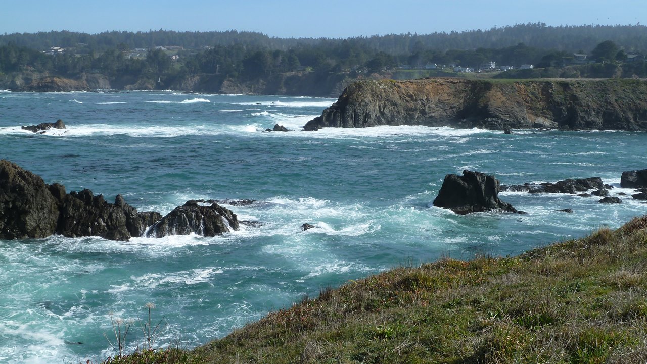
The next day we headed further south and spent an hour or so enjoying one of my favourite stops on the northern California coast -- the headlands in Mendocino, California. This is an unbelievably beautiful place with walking trails all along the cliffs. 


From Mendocino we headed inland towards the Napa Valley. Up and over the coast mountains. Vineyards begin to appear as soon as you're just a short way back from the coast and continue pretty much all along the road to Napa. We ended up in the St. Helena for our next overnight. The state parks in California (the ones I've seen at least) don't compare well with the ones in Oregon. In Oregon, you get electricity, water at your site and hot showers. All for their winter rates which average about $20. In the state park near St. Helena, it cost $35 for a site with no facilities and, insult of insults, the park had coin operated showers. No surprise that there were few campers that night.

From the Napa Valley we drove cross country on Hwy 12 to Hwy 99 which runs down to Bakersfield and eventually connects with Interstate Hwy 5. There seemed to be very few options for campers so we ended up staying at a Super 8 motel here in Bakersfield. Just as well, I hadn't had a shower since Harris Beach in Oregon. And there was wi-fi access so I was finally able to figure out my connection problem ... or at least a work around for it.

We'll be heading east into the mountains for some relief from the forecast blistering temperatures. Temperatures are forecast to be in the mid-30C in Death Valley so I think we will have to skip that destination as I'm not sure the van or the dog or myself are up for that kind of heat. In a week's time the long range forecast is for much cooler temperatures so I guess we'll just have to wait and see.